
Every tips and information about WAEC Geography Questions and Answers 2025 | Essay and Objective have been made available in this article that you are about to read. Just pay attention and read closely to the end if you wouldn’t want miss out.
This article is for all the candidates who will be writing Geography in the 2025 MAY/JUNE WAEC Examination. Therefore, if you belong to this class of individuals or you have someone who is going to participate in the examination, ensure that you read this article and share it to all your colleague.
The expected WAEC Geography Questions and correct answers are now online and they are going to be made available to only followers of this website. As usual, the examination has two different sections; the Essay part and the Objective part.
Here, I am going to reveal to you all the questions and answers and also show you some necessary tips that you are going to apply in tackling any kind of geography examination at all level.
Continue to read this article if you would like to know more about this article.
WAEC Geography Objective Questions 2025
The following are the Geography objective questions that you are likely going to see in the forthcoming WAEC examination:
Study the map of ODU DISTRICT below and use it to answer questions 1 – 10
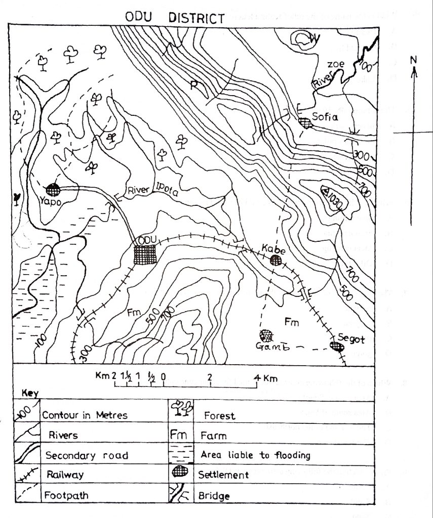
- What is the approximate distance by rail from Kabe to Odu?
A. 9.0 km
B. 8.0 km
C. 6.0 km
D. 4.0 km - The direction of ODU from Sofia is
A. southwest.
B. cast.
C. northwest.
D. south. - What is the scale of the map expressed as Representative Fraction (R.F.)?
A. 1:25,000
B. 1:50,000
C. 1: 100,000
D. 1:250,000
4. What is the name of the relief feature lettered W?
A. Headland
B. Conical hill
C. Plateau
D. Lake
- The symbol A 1030 represents a
A. bench mark.
B. boundary pillar.
C. trigonometrical station.
D. beacon. - Which of the following industries could be set up in Yapo?
A. Saw milling
B. Fruit canning
C. Meat canning
D. Oil refining - The long stretch of highland to the northeastern part of the map is a
A. caldera.
B. canyon.
C. ridge.
D. gorge. - Which of the following arcas is best suited for sugar cane cultivation?
A. Area around Segot
B. Area south of Yapo
C. The lowland of the northeast
D. The forest arca - From which of the following settlements is ODU visible?
A. Gamb
B. Segot
C. Yapo
D. Sofia - ODU is most likely to be important trading centre because it is
A. a nodal centre.
B. a fish canning town
C. a mining town
D. close to a port
11. If a map has a scale of 1: 50,000 and a cocoa plantation is represented on the map by a rectangle 5 cm by 4 cm, what is the area of the plantation?
A. 5 km2
B.6km2
C. 20km2
D. 25km2.
12. On which of the following pairs of dates is the length of day and night equal on the earth’s surface?
A. June 21st and September 21st
B. March 22nd and December 22nd
C. June 21st and December 22nd
D. March 21st and September 23rd.
13. Lakes formed as a result of landslides, screes or avalanches are known as _____
A. man-made lakes
B. barrier lakes
C. caldera lakes
D. rock-hollow lakes.
14. Which of the following is a major environmental problem in heavily industrialized regions?
A. Accelerated erosion
B. Water pollution
C. Frost damage
D. acid rain.
15. The crossing of a boundary between two countries by a migrant is best described as ____
A. emigration
B. Immigration
C. Out-migration
D. international migration.
16. A process whereby a plant community is replaced by another is known as ________
A. colonization
B. succession
C. competition
D. consolidation.
17. The duration of sunshine is measured by the ______
A. aneroid barometer
B. Campbell-Stokes recorder
C. cup-anemometer
D. minimum-maximum thermometers.
18. Quartz, feldspar and mica are three principal minerals that can easily be seen in _____
A. basalt
B. coal
C. granite
D. limestone.
19. The rock with the least carbon content is ______
A. Coal
B. Sandstone
C. marble
D. lignite.
20. The process by which organic matter is decomposed and synthesized to form part of the soil is known as ______
A. humification
B. mineralization
C. lateralization
D. nitrification.
21. Which of the following groups consists of energy resources?
A. Petroleum, uranium and manganese
B. Coal, bauxite and uranium
C. Water, copper and sun
D. Coal, petroleum and water.
22. A piece of evidence that confirms that the earth is spherical is _______
A. Standard time
B. solar system
C. earth’s orbit
D. moon’s eclipse.
23. A tremendous pressure or temperature change may lead to the formation of ______
A. limestone
B. granite
C. gneiss
D. clay.
24. Which of the following sources of power supply is renewable?
A. Solar
B. Coal
C. Gas
D. Nuclear.
25. Hygrometer is used to measure ______
A. rainfall
B. wind direction
C. relative humidity
D. sunshine.
26. The largest ocean in the world is the _______
A. Atlantic Ocean
B. Indian Ocean
C. Arctic Ocean
D. Pacific Ocean.
27. Rock minerals are said to be crystalline when the atoms forming them are _______
A. found in sedimentary rocks
B. found in crystalline rocks
C. arranged in a definite pattern
D. arranged vertically.
28. The difference in time between two longitudes is approximately ______
A. 15 hours
B. 40 minutes
C. 4 hours
D. 4 minutes.
29. A slope is said to be even when the contours are _________
A. equally spaced
B. concentric
C. closely spaced
D. irregularly spaced.
30. Which of the following is the most important agent of erosion in humid regions?
A. Fog
B. Wind
C. Ice
D. Running water
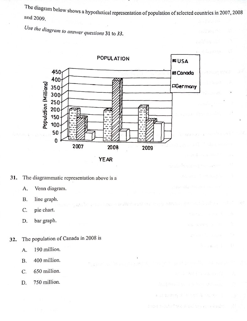
- By how much did the population of Germany grow between 2008 and 2009?
A.
10 million
B. 50 million
C. 120 million
D. 400 million - Water pollution is caused by all the following except
A. treated sewage.
B. industrial waste.
C. oil spillage.
D. fishing with chemicals. - “The climate is constantly warm, rainfall is relatively abundant with double maxima, there is no month without rain. These are the characteristics of the
A. Monsoon climate.
B. Warm temperate climate.
C. Equatorial climate.
D. Mediterranean climate. - Which of the following climatic types has the smallest annual range of temperature?
A. Cool temperate
B. Warm temperate
C. Tropical desert
D. Equatorial - Which of the following is the first stage in the process of lumbering?
A. Trees are cut into logs.
B. Suitable species are identified.
C. Trees are felled with power saw.
D. Platforms are built for butress trees. - Which of the following criteria is not important in distinguishing between a village and a town?
A. Geographical situation
B. Population size
C. Social amenities
D. Variety of activities - The number of persons per square kilometre of land is called
A. total population.
B. high population.
C. population density.
D. optimum population. - Which of the following is a disadvantage of high population density?
A. Unemployment
B. Low crime rate
C. Low pressure on social amenities
D. Regular flow of traffic - Which factor of industrial location explains the establishment of cement industries near areas of limestone deposit? Proximity to
A. power
B. source of raw materials
C. market
D. income sources - Which of the following modes of transportation provides door-to-door services?
A. Road transport
B. Rail transport
C. Occan navigation
D. Air transport
- African rivers exhibit the following characteristics except
A. that they have their sources in the interior highlands.
B. C. the presence of rapids and waterfalls on their courses. that they exhibit seasonal variations in water volume.
D. that they have great depths. - What method of mining is used for extracting petroleum in Africa?
A. Crushing
B. Drilling
C. Adit
D. Open cast - What factor accounts for the slow rate of industrial development in Tropical Africa?
A. Inadequate capital
B. Availability of essential social services
C. Adequate skilled labour
D. Modern technology - What is the name of the local wind that blows in West Africa between November and February?
A. Harmattan
B. Chinook
C. Monsoon wind
D. Land breeze - Which of the following vegetation belts in Africa is the most extensive?
A. Mediterranean forest
B. Temperate grassland
C. Savannah
D. Temperate forest
- Through which of the following sea routes is crude oil from West Africa transported to European markets?
A. The Panama Canal route
B. The Cape route
C. The Suez Canal route
D. The North Atlantic route - Which of the following towns has winter rainfall and summer drought?
A. Banjul
B. Cape Town
C. Lagos
D. Accra - Favourable factors for lumbering in Africa include all the following except
A. high demand for tropical timber.
B. presence of many economic trees.
C. high demand for fuel wood.
D. inaccessible equatorial forest.
WAEC Geography Objective Answers 2025
The correct answers to the WAEC Geography objective questions given in the previous section are as shown below:
- 8.0km (B)
- East (B)
- 1: 25,000 (A)
- Conical hill (B)
More Answers Loading >>…
WAEC Geography Theory Questions 2025
- Study the map extract on the scale of 1:50,000 and answer the following question. (you will be given the map inside the examination hall)
(a) Draw an annotated cross profile along line X-Y.
[ 8 marks
(b) Describe the settlement pattern on the mapped arca.
[4 marks]
(c) Calculate the full length of river Jamtari. (d) List three man-made features and three physical features in the area
[4 marks]
marked by rectangle ABCD.
[ 6 marks]
2.
Four Economic Community of West African States (ECOWAS) member countries contributed to a capital project in the sub-region in 2007 as shown below:
| Country | Annual Contribution ($) |
| A B C D | 50,000 150,000 110,000 90,000 |
(a) Illustrate the information above in a pic chart.
[12 marks]
(b) State two advantages of using pic chart.
[4 marks]
3. (a) With the aid of diagrams, explain the following terms in relation to the shape of the earth.
(i) Sunrise and sunset. [ 6 marks]
(ii) Circumnavigation.
[ 6 marks]
(b) Calculate the distance between town A (latitude 5 °N) and town B (latitude 10 °N) if they are both situated on the same meridian.
[4 marks]
4.
(a) With the aid of diagrams, describe one mode of formation of a block mountain.
[8 marks]
(b) In what four ways are mountains of economic importance?
[8 marks]
5.
(a) Define the term weathering.
[4 marks]
(b) Describe four processes of chemical weathering.
[12 marks]
6.
(a) List any two types of delta.
[2 marks]
(b) Explain four conditions favourable for the formation of delta.
[ 8 marks]
(c) Describe three main characteristics of a delta.
[ 6 marks]
7.
Write explanatory notes on flooding under the following:
(a) arcas of occurrence;
[2 marks]
(b) causes;
[ 6 marks]
(c) negative effects;
[ 6 marks]
(d) control.
[2 marks]
8.
(a) Define ecosystem.
[2 marks]
(b) Describe any four ways in which man has interfered with the ecosystem.
[8 marks]
(c) With specific examples, outline three effects of man’s interference with the ecosystem.
[ 6 marks]
WAEC Geography Theory Answers 2025
Now that you have seen all the WAEC Geography Theory Questions for 2024 examination, it is time to help you provide all the correct answers. Hope you are excited about the information.
Keep reading till the end!
2. a
| Country | Annual Contribution ($) | % Annual Contribution (%) |
| A B C D | 50,000 150,000 110,000 90,000 | 12 37 28 23 |
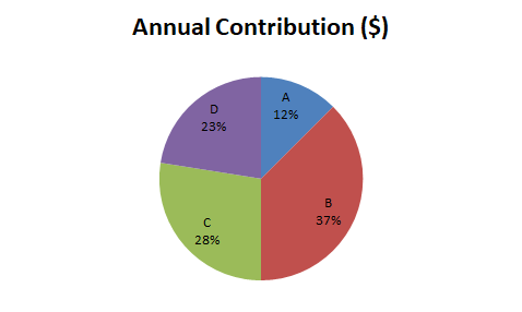
NOTE: You don’t have to paint your own drawing during the examination
b. Advantages of using Pie Chart (Select any two below)
- display relative proportions of multiple classes of data.
- size of the circle can be made proportional to the total quantity it represents.
- summarize a large data set in visual form.
- be visually simpler than other types of graphs.
- permit a visual check of the reasonableness or accuracy of calculations.
Keep refreshing this page for more answers…
Recommended Posts:
WAEC English Questions And Answers 2025 | Objectives, Test Of Orals and Essay
WAEC Economics Questions And Answers 2025 | Theories And Objectives
WAEC French Questions And Answers 2025 | Theories And Objectives
WAEC Mathematics Questions And Answers 2025 | Theory And Objectives
WAEC Physics Practical For 2025 | Specimens/Apparatus, Questions And Answers
WAEC Chemistry Questions And Answers For 2025 | Objectives And Theories
2025 WAEC Biology Practical Specimen | Questions And Answers
Complete WAEC Physics Questions And Answers For 2025 (Objectives & Theory)
Tips On How To Pass WAEC Geography
If you had written WAEC Geography examination before but could not make at the first attempt or this is going to be your first time to sit for Geography examination in WAEC and you would like to pass the examination at one sitting, ensure that you apply all the tips that I am going to reveal to you here.
Use WAEC Syllabus
It has been proven that at least 95% of every WAEC Geography examination questions come from the topic and areas stated in the WAEC Geography syllabus. This has been a helpful tip for successful candidates of the examination over the years. It advisable that you read you books in line with the syllabus if you really want to make a good result in WAEC Geography.
Study Map Reading
This is the base rock of all WAEC or NECO Geography examination. Amongst all the topics that you will be reading in geography textbooks, endeavour to read, practice and understand map reading very well before entering the examination hall.
Study Past Questions on WAEC Geography
The benefits of studying Geography Past questions during your preparation periods cannot be over emphasized. First, it helps candidate to boost his/her confidence in facing the real examination. This is because WAEC geography questions can be changed but the mode of asking the questions is more or less the same for all the years.
Also, most times, WAEC geography questions could be repeated. In this case, if you have been studying your past questions very well, answering any repeated question will not be challenging to you.
I believe that you have read this article to the end and have found it helpful. In case of any other questions about WAEC Geography Questions And Answers 2025, kindly make use of the comment section below this article.
Do well to share this article using any of the buttons below.